User Interface
|
[en] English,
[ru] Russian,
[ua] Ukrainian,
[by] Belarusian,
[es] Spanish,
[lv] Latvian,
[de] German,
[hu] Hungarian,
[pt] Portuguese,
[no] Norwegian,
[lt] Lithuanian,
[nl] Dutch-Netherlands and
[ro] Romanian translations.
Window and its components can be stretched.
You can hide all panels that are not needed.
You can drag columns in the file list and sort list by any of them.
You can drag video files on the program window and they will be added to the list.
Playing the files, passed to the command-line at startup.
Saving all settings: windows position, size of panels, file list view, etc.
The Metric system (meters, kilometers) and the British Imperial system (feet, miles).
|
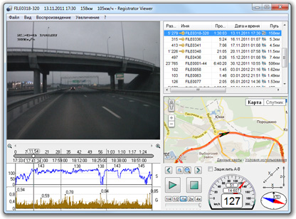 |
Records
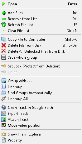
All-In context menu
|
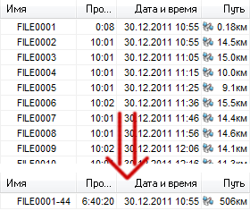
Grouping of files - pieces of a trip can be watched as single record.
Files are searched automatically.
Copying files to the computer. Dates of file are saved, which is useful for future viewing, especially for files without GPS.
Deleting files from memory card.
Lock and unlock files to protect from overwriting.
Detailed properties of the video and GPS data.
|
Maps
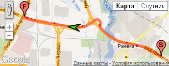 |
Google Maps, Open Street Maps, Bing Maps.
Displaying the whole route and arrow with the current position and direction.
You can click on the route, and video seek to this time, when you were driving at a given point.
You can change the size of the arrows on the map.
Timestamps on the route.
|
GPS Supported for Video Registrators:
|
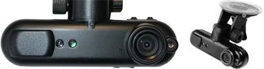
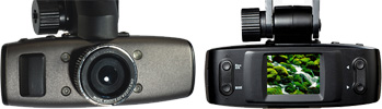
KAPKAM Q3 (Carcam, Karkam)
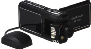
DATAKAM GS-600
DOD GS600
and analogues
| 
|
| KAPKAM Q4
| 
|
KAPKAM Q5
DOD GSE550
ACV Q5
and analogues
| 
|
Samoon DV5E5
GS1000
TeXet DVR 1GP
and analogues
| 
|
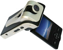
| DATAKAM GS-800
| 
|
GPS1000
DVR DS103
| 
|
| BlackVue DR400G
| 
|
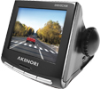
Akenori DriveCam 1080 Pro
Papago P2
| 
|
| Digma DVR-105G
| 
|
| MagicEye FG720
| 
|
| SymDVR
|

|
Program will make dash cam from
your smartphone based on Symbian S60
|

| SymDVR site
|
|
Roadline G9
Vosonic Flexmedia V747W
Ritmix AVR-820
GPS1000A
GS2000
GS5000
GS8000
GS9000
Tenex DVR 520
RoadHawkHD
Texet DVR-1GS
F70G
F90G
|
|
| Your camera has a GPS, but it is not in this list? |
• GPS displayed correctly
Please, let us know about it.
Then your model will be added to the list.
Send the e-mail to
vadikus@mail.ru
|
| • This program does not show GPS data
Please, send sample files.
I'm interested to support any camera with GPS.
You can send only files containing GPS data, but write details about the structure of the generated folders and files.
If possible, take a short record (about one minute) on clean memory card and then compress everything
what appeared on the card and send the archive.
It is advisable to send video files with sound, just to verify that the clippings are working properly.
Any additional information and details about your camera will help to support it.
If your dash cam has a special player, then send it, if possible, or send the link where it can be downloaded.
You can send files as attach to
vadikus@mail.ru
or upload it to any files storage.
|
GPS
You can attach an external file with the GPS track (*.gpx, *.plt, *.nmea), for example, in the case of video recording apart from GPS recording.
Support altitude, if this information is recorded by the registrator.
Calculation of the trip distance.
Export tracks to formats:
KML (for Google Earth),
CSV (for Excel),
GPX (GPS eXchange Format),
PLT (Ozi Explorer).
Generating SRT subtitles, containing GPS information. They can be attached to the video on YouTube, as well as they accepting by many players: VLC, MPC, MPlayer, CrystalPlayer, DirectVobSub, ...
Playback
Various video conversions:
- Stretch video to all of the available area of the window, with save aspect ratio or don't save.
- Zoom in and zoom out the video, change the scale as you wish.
- Reflect video horizontally or vertically. Together - rotate by 180 degrees to view the records, if the registrator was hanged upside down.
Save screenshots (single video frames).
Variable playback speed (does not always work well for some reason).
Loop AB.
Frame by frame viewing.
Seek video by left and right arrows on your keyboard.
Pause on click and by space key.
Play the file list in the loop.
Supported EVR - Enhanced Video Renderer (only for Windows Vista / 7)
Hardware decoding video, using the graphic card. If the processor does not enough for HD (old PC or new netbook), but the graphic card are new, it will be play HD without brakes.
Non-linear stretch with saving aspect ratio in the center - a convenient projection of video, to watch HD 1920x1080 on standard (square) monitor.
Stretching of video is smooth and performing by video card. That is there is no "squares" when zoom in.
You can even stretch video on two monitors.
Video Fragments
Save any part of the trip without recompression for MOV and MP4 formats.
- Cutting fragments.
- Joining blocks to single file.
It is possible to cut without sound.
Cutting related GPS information is also made.
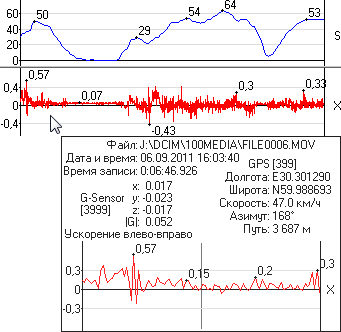
Graphs
Customizable set of graphs:
- Speed.
- Altitude.
- X, Z, Y projections and the total vector of the vibrations G-Sensor (acceleration sensor).
The graphs show the local maximums.
Zoom in and the movement on the graphs and time line.
Pop-up window with an increased graph and detailed information about all of the measured values at given point.
|
 |
2013 © Vadikus Production
|
 RU |
RU |  EN
EN